
Geography and Climate of Abuja
Geography and Climate of Abuja
A Capital Shaped by Land and Sky
Abuja’s identity is deeply tied to its geography. Unlike many Nigerian cities that grew organically around rivers or trade routes, Abuja was deliberately chosen for its central location, stable terrain, and balanced climate.
The land itself influenced everything—from city planning and architecture to population growth and daily life. To understand Abuja, you must first understand its land and weather.
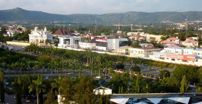
Geographical Location
Abuja sits at the very heart of Nigeria, both geographically and symbolically.
Central Position: Located roughly in the center of the country, Abuja is equidistant from Nigeria’s major regions, reinforcing its role as a neutral national capital.
Coordinates: Approximately 9.0765° N latitude and 7.3986° E longitude.
Boundaries: The Federal Capital Territory borders Niger State to the north and west, Nasarawa State to the east, and Kogi State to the south.
Land Area: The FCT covers about 8,000 square kilometers, making it one of Nigeria’s smaller administrative regions by size.
Topography: Hills, Valleys, and Open Plains
Abuja’s landscape is far from flat. Rolling hills, rocky outcrops, and wide valleys define the terrain.
Rock Formations and Hills
Aso Rock: The most famous monolith in Abuja, rising over 400 meters above sea level. It dominates the city’s skyline and houses Nigeria’s seat of power.
Zuma Rock: Located just outside the city, Zuma Rock towers over the landscape and is one of Nigeria’s most iconic natural landmarks.
Katampe and Mpape Hills: These rocky elevations shape nearby districts and provide scenic views of the city.
Gwagwa and Karshi Hills: Smaller hill ranges that contribute to Abuja’s rugged beauty.
Plains and Valleys
Between the hills lie broad valleys and plains that made large-scale urban planning possible.
Central Plains: These flat areas were ideal for government districts, roads, and infrastructure.
Floodplains: Some low-lying areas require drainage management during the rainy season.
Rivers and Water Bodies
Although Abuja is not a river-based city, water bodies still play an important role.
River Usuma: One of the most significant rivers in the FCT, supplying water to the city through the Lower Usuma Dam.
Jabi Lake: A man-made lake that has become a recreational and commercial hub.
Seasonal Streams: Numerous smaller streams flow during the rainy season, shaping local drainage systems.
Dams and Reservoirs: Critical to water supply and urban sustainability.
Vegetation and Natural Environment
Abuja lies within Nigeria’s Guinea Savannah ecological zone.
Vegetation: Tall grasses, scattered trees, and shrubs dominate the landscape.
Common Trees: Shea butter trees, locust beans, acacia, and baobab can be found in surrounding areas.
Wildlife: While urbanization has reduced wildlife, smaller animals and birds still inhabit the outskirts.
Green Zones: Parks and green belts were integrated into Abuja’s master plan.
Climate Overview
Abuja enjoys a tropical savanna climate, often described as one of the most comfortable in Nigeria.
Seasons
Rainy Season: April to October, with peak rainfall between July and September.
Dry Season: November to March, marked by low humidity.
Harmattan: A dry, dusty wind from the Sahara, typically between December and February.
Temperature
Average Range: Between 18°C and 35°C throughout the year.
Cooler Nights: Especially during the harmattan season.
Hottest Months: March and April, just before the rains begin.
Mild Evenings: One of Abuja’s most praised climate features.
Rainfall and Weather Patterns
Rainfall shapes agriculture, water supply, and daily movement in the city.
Annual Rainfall: Approximately 1,100 – 1,600 mm.
Storms: Heavy rains often arrive suddenly but are usually short-lived.
Urban Drainage: Proper drainage is essential to prevent flooding in low-lying districts.
Seasonal Rhythm: Life in Abuja follows the rhythm of dry and wet seasons.
How Geography Shapes the City
Abuja’s geography directly influenced its planning and development.
District Zoning: Hills and valleys guided where districts, highways, and green areas were placed.
Road Networks: Roads follow natural contours to reduce construction challenges.
Security: Elevated terrain around key government zones offers natural security advantages.
Expansion Limits: Some rocky areas slow development, shaping growth patterns.
A City Balanced by Nature
Abuja’s geography offers a rare balance—open land for expansion, hills for beauty and security, and a climate that supports comfortable living.
While rapid growth continues to pressure natural systems, Abuja remains one of Nigeria’s most geographically fortunate cities.
The land beneath Abuja is not just a foundation for buildings—it is the quiet force that shaped the capital itself.